


Stubble burn area estimation and its impact on ambient air quality of Patiala & Ludhiana district, Punjab, India
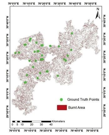
| Abstract | Stubble burning during October and November, results in the extensive formation of smoke cloud over the Punjab region, and maybe one of the main reasons behind the increase in air pollution levels in these areas. The manual detection and estimation are tedious, lengthy and unpractical, so several researchers have been using remote sensing and GIS technique to estimate stubble burn areas and forest fires. Thus, in the present study, an attempt has been made to detect and estimate the stubble burn area. Landsat 8 OLI images are used to detect the stubble burn area for the year 2014-18 for Patiala and Ludhiana, which are major rice producing districts of Punjab. Normalize Burn Ratio (NBR) index have been used to determine the burned area in an image using a statistical threshold technique (2σ approach). The results have been validated using available as well as collected Ground Control Points (GCPs) and accuracy assessment has been conducted by generating an error matrix. It has been estimated that the stubble burn area was reduced by 32% and 40% during the study period for Patiala and Ludhiana regions, respectively. The monthly variation for various pollutants (RSPM, NOx, and SO2) during the study period has also been studied and analyzed. The distinct increase in pollutant levels has been observed during each stubble burning period. The results also indicate that the amount of emitted RSPM and NOx was higher than the emitted SO2 during stubble burning. The wind rose diagrams have also been plotted. |
| Faculty |
Dr. Har Amrit Singh Sandhu
|
|
hassandhu@pec.edu.in
|
|
| Collaborations | Pratika Chawla |
| More Information | DOI: https://doi.org/10.1016/j.heliyon.2019.e03095 |